

Six Legendary Mountain Passes That Shaped Cycling
Cycling was forged on roads that rise.
Long before aerodynamics, data screens and marginal gains, riders proved themselves against gravity. The great mountain passes of Europe are more than demanding stretches of tarmac. They are monuments to endurance. They have defined champions, broken contenders and offered everyday cyclists a rare measure of themselves.
The mythology of the sport was built in the Alps and the Pyrenees, in the thin air of the Tour de France and the drama of the Giro d'Italia. To ride these climbs is to touch that history directly. Not through nostalgia, but through effort.
Here are six ascents that continue to define cycling’s highest ideals.
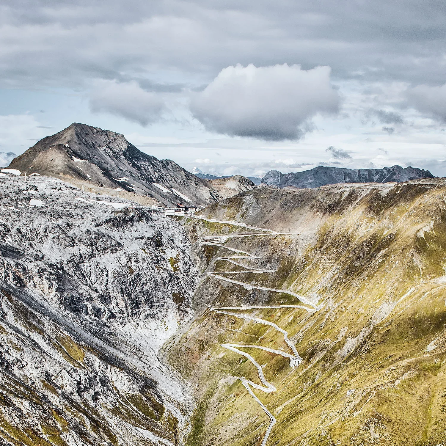
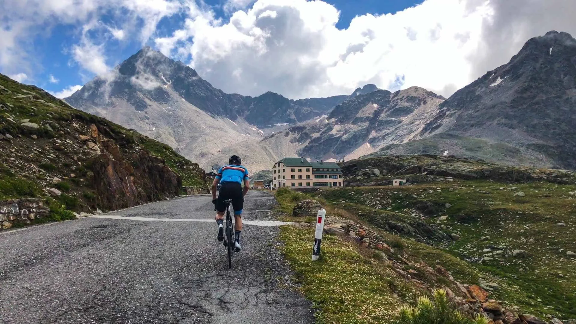
Passo dello Stelvio: Italy
Altitude: 2,757 m
Distance: 24.3 km (from Prato allo Stelvio)
Average gradient: 7.4%
Elevation gain: approx. 1,808 m
Start: Prato allo Stelvio
Finish: Stelvio summit, South Tyrol
Few roads look as improbable as the Stelvio. Forty-eight numbered hairpins stack precisely against the mountainside, tracing a near-perfect line toward the sky. When the Giro passes here, it often crowns the Cima Coppi, the highest point of the race.
The gradient is steady rather than savage. It rewards patience, cadence control and restraint. Pacing on long climbs reduces lactate accumulation and preserves muscular efficiency. The Stelvio teaches exactly that. Each switchback invites you to settle, breathe and hold your line.
What surrounds it:
Alpine villages shaped by both Italian and Austrian heritage, glacier views and traditional mountain cuisine. In summer, the summit becomes a meeting point for cyclists from across the world.
Practical advice:
Start early to avoid traffic. Even in warm months, temperatures at altitude drop quickly. A light gilet for the descent is not optional.
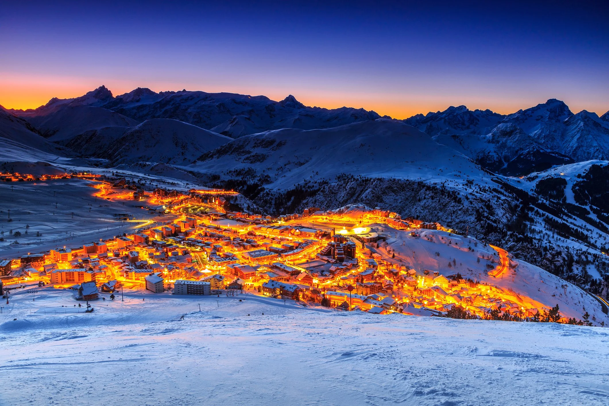
Alpe d’Huez: France
Altitude: 1,860 m
Distance: 13.8 km
Average gradient: 8.1%
Elevation gain: approx. 1,120 m
Start: Bourg d’Oisans
Finish: Alpe d’Huez ski station
Twenty-one bends. Each numbered. Each bearing the name of a stage winner from the Tour. Alpe d’Huez compresses drama into 14 kilometres.
The opening kilometres are the steepest. The road rises abruptly from the valley, forcing riders to find rhythm immediately. It is a climb that punishes impatience.
What surrounds it:
The town at the summit breathes cycling culture. cafés filled with riders discussing times and tactics and access to other Alpine giants nearby.
Practical advice:
Control the first three kilometres. Find a sustainable rhythm. The climb is as much psychological as physical, especially when summer crowds line the barriers during race season. Pair it with neighbouring passes for a complete Alpine experience.
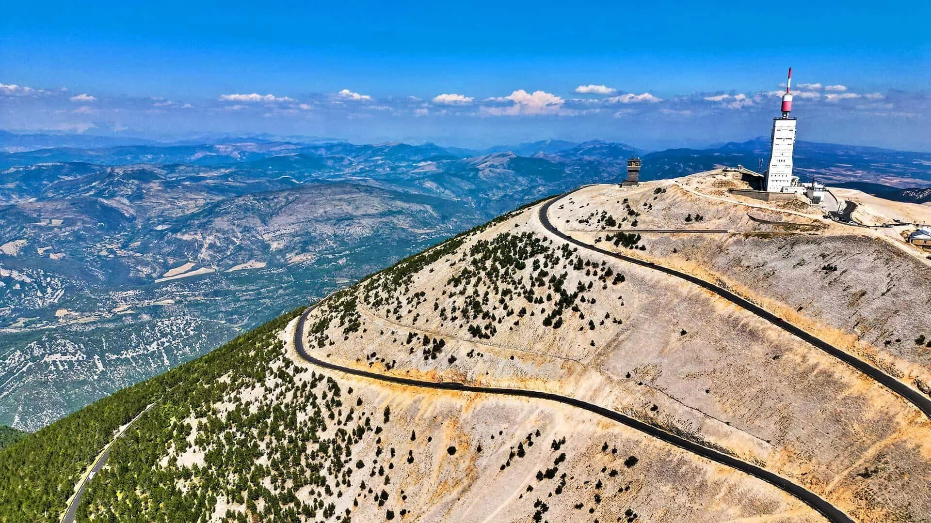
Mont Ventoux: France
Altitude: 1,909 m
Distance: 21.5 km (from Bédoin)
Average gradient: 7.4%
Elevation gain: approx. 1,610 m
Start: Bédoin, Provence
Finish: Ventoux summit
They call it the Giant of Provence. The lower slopes from Bédoin are sheltered by forest, steady and contained. Then the trees disappear. The final six kilometres unfold across exposed pale limestone, where wind replaces gradient as the primary adversary.
Ventoux has delivered some of the most dramatic chapters in Tour history. It is a mountain that demands humility.
What surrounds it:
Provençal villages, vineyards, lavender fields in season and a strong cycling community rooted in tradition.
Practical advice:
Check the wind forecast carefully. Carry sufficient water. The exposed upper section offers no protection from sun or gusts.
When you crest the summit, look back. The landscape opens wide, reminding you that performance is not only about numbers. It is about perspective.
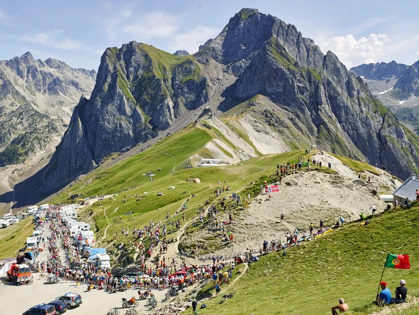
Col du Tourmalet: France
Altitude: 2,115 m
Distance: 19 km (from Luz-Saint-Sauveur)
Average gradient: 7.4%
Elevation gain: approx. 1,400 m
Start: Luz-Saint-Sauveur or Sainte-Marie-de-Campan
Finish: Tourmalet summit, Pyrenees
The most frequently used mountain pass in Tour de France history. The Tourmalet represents the early spirit of the sport — narrow roads, shifting weather and gradients earned through persistence rather than spectacle.
Both sides offer distinct character. From Luz-Saint-Sauveur, the ascent builds progressively. From Sainte-Marie-de-Campan, it tightens in its final kilometres towards La Mongie.
What surrounds it:
Traditional Pyrenean villages, thermal baths and high pastureland. The summit statue of Octave Lapize stands as a reminder of cycling’s pioneers.
Practical advice:
Weather changes rapidly in the Pyrenees. Bring layers. Descend with care, sections are fast and technical.
Passo di Gavia: Italy
Altitude: 2,621 m
Distance: 25.6 km (from Ponte di Legno)
Average gradient: 5.5% (with steeper upper sections)
Elevation gain: approx. 1,360 m
Start: Ponte di Legno or Santa Caterina Valfurva
Finish: Gavia summit (Lombardy)
The Gavia is less polished than the Stelvio, and perhaps more authentic because of it. Narrow sections, exposed stretches and dramatic alpine scenery define the experience. It became legendary after the snowbound Giro d’Italia stage of 1988, when riders climbed through a blizzard.
It is not merely a climb; it is an immersion.
What you will find around it
Remote alpine landscapes, glacial lakes near the summit and traditional Lombard mountain culture. It can feel quieter and more solitary than its famous neighbour, the Stelvio.
Practical advice
Road surfaces can vary. Descend with caution. Weather shifts quickly at altitude. Ideal as part of a multi-pass challenge including the Stelvio and Mortirolo.
Passo del Mortirolo: Italy
Altitude: 1,852 m
Distance: 12.4 km (from Mazzo di Valtellina)
Average gradient: 10.5%
Elevation gain: approx. 1,300 m
Start: Mazzo di Valtellina (Lombardy)
Finish: Passo del Mortirolo summitIf the Stelvio is majestic, the Mortirolo is relentless. From Mazzo di Valtellina, its ramps frequently exceed 12 percent, with pitches approaching 18. There is little room for recovery. Cadence drops. Heart rate rises.
Steep gradients place greater torque demands on the knees and hips, increasing muscular strain. Proper gearing and controlled pacing are essential. This is not a climb for ego. It is a climb for discipline.
The Mortirolo has decided the Giro more than once. It does not offer wide panoramas or sweeping vistas. Its beauty lies in its severity.
What surrounds it:
Dense forest lines much of the ascent from Mazzo, the road narrow and intimate, with little distraction beyond the sound of breathing and drivetrain. Small stone villages rest in the valley below, rooted in Lombardy’s rural character. The atmosphere is austere, almost monastic.
Practical Advice:
Choose your gearing carefully.
Compact chainrings and a wide cassette are not signs of weakness on slopes that regularly exceed 12 percent. Descend with caution, the road is narrow, technical and occasionally uneven.
Col du Galibier: France
Altitude: 2,642 m
Distance: 17.7 km (from Valloire)
Average gradient: 6.9%
Elevation gain: approx. 1,245 m
Start: Valloire (Savoie)
Finish: Col du Galibier summit
The Galibier is monumental. Rising high above the tree line, it feels expansive from the very first kilometres. The ascent from Valloire builds gradually before tightening in the final eight kilometres, where altitude begins to assert itself. Above 2,000 metres, oxygen availability decreases and even steady efforts demand composure.
The Galibier has shaped decisive moments in the Tour de France for over a century. Its scale is not only physical but historical. The final approach, often framed by snow walls well into early summer, carries a quiet gravity. It is less explosive than other Alpine climbs, yet more consuming.
What surrounds it:
The Galibier connects the Col du Lautaret with the Maurienne valley, forming part of one of the most iconic high-mountain routes in the Alps. Vast alpine meadows, raw rock faces, and distant glaciers define the landscape. Marmots dart between stones. The air feels thinner, cleaner, stripped of distraction. On clear days, the summit offers sweeping views deep into the Écrins massif. It is a place that feels genuinely high and unapologetically exposed.
Practical advice:
Respect the altitude. Pace conservatively in the lower half and allow effort to rise gradually. Weather can change quickly, even in July. Carry wind protection for the descent, as temperatures drop significantly near the summit. The road is wide but fast on the way down, so descend with focus and restraint.
Where Mountains Meet Meaning
These climbs are not bucket-list trophies. They are experiences that shape you.
They demand preparation, thoughtful pacing and respect for conditions. Performance equipment designed for freedom of movement and long hours in the saddle becomes part of the dialogue between rider and road. Not as ornament, but as support.
In the end, the mountains give something back: perspective, community at the summit, a shared nod between strangers who have climbed the same road.
Cycling was shaped in these places and each time we ride upward, whether in the Alps, the Pyrenees, or closer to home, we participate in that lineage.
The road tilts. The world narrows to breath and rhythm. And in that quiet effort, we find what first drew us to the bike.